|
MAPS FOR SALE:
High Plains Mapping has the following
products for sale:
Montana Historical Maps display
historical points of interest on a county-by-county basis. The maps are the
result of meticulous research, and are drawn in an attractive, easy-to-read
format. Historic sites on the maps include:
Towns
Rural Schools (Closed and Current)
Post Offices
Settlements
Pioneer Ranches (Before 1900)
Roads and Trails
Forts and Trading Posts
Battles and Skirmishes
Noteworthy Incidents
A comprehensive historical inventory on
one sheet. Also included are a selection of area pioneer brands, along with an
index source list, and acknowledgements.
The following Montana
Counties are available for $12.00 each:
-
Valley County (Glasgow):
5,061 sq. mi.; 270 historic sites; 23" x 35"; printed on fine woven linen
paper.
-
Phillips County (Malta): 5,211 sq. mi.; 299 historic sites; 23" x 35"; printed
on fine woven linen paper.
-
Cascade County (Great Falls): 2,711 sq. mi; 280 historic sites; 35" x 23";
fine woven linen paper or aged parchtone cover-stock (very durable).
-
Fergus County (Lewistown): 4,350 sq. mi; 360 historic sites; 35" x 23" fine
woven linen paper.
-
Wibaux County (Wibaux): 890 sq. mi.; 124 historic sites; 17" x 23" fine woven
linen paper.
-
Rosebud County (Forsyth): 5,026 sq. mi.; 386 historic sites; 23" x 35"; fine
woven linen paper.
-
Richland County (Sidney): 2,103 sq. mi.; 305 historic sites; double-sided:
historical sketch, brands, and index on reverse; 23"x 17"; fine woven linen
paper.
-
Yellowstone County (Billings): 2,648 sq. mi.; 540 historic sites; double
sided: Billings-Laurel inset, brands, and index on reverse; 35" x 23"; printed
on aged parchtone cover-stock.
-
Treasure County (Hysham): 984 sq. mi.; 145 historic sites; 17" x 23"; printed
on aged parchtone cover-stock.
-
Fallon County (Baker): 1,622 sq. mi.; 180 historic sites; 17" x 23"; printed
on aged parchtone cover-stock.
-
Chouteau County (Fort Benton): 3,996 sq. mi.; 722 historic sites; double
sided: Ft. Benton-Judith Landing Missouri River detail, rivercraft
illustrations and pertinent artwork, sources and acknowledgements on reverse;
separate index booklet; printed on aged parchtone cover-stock. $20.00.
On the reverse side is a comprehensive index using appropriate symbols and a
dramatic1855 illustration of a tribal hunter on horseback taking aim with bow
and arrow. Printed on aged parchtone paper. $15.00.
-
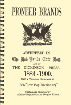 Pioneer Brands Advertised in the Bad Lands Cowboy and the Dickinson
Press,1883-1900, by Michael Bugenstein and Douglas Ellison. Replica of late-19th
century brand book using brand cuts from frontier newspapers. Brands include:
Theodore Roosevelt, Marquis De Mores, Wadswoth, Quinion, and OX and 777 (Texas
cattle outfits). Also included is a historical sketch and an 1885 “Cow Boy
Dictionary” from the Medora Bad Lands Cow Boy in original type.
Wire-bound. $9.95. Pioneer Brands Advertised in the Bad Lands Cowboy and the Dickinson
Press,1883-1900, by Michael Bugenstein and Douglas Ellison. Replica of late-19th
century brand book using brand cuts from frontier newspapers. Brands include:
Theodore Roosevelt, Marquis De Mores, Wadswoth, Quinion, and OX and 777 (Texas
cattle outfits). Also included is a historical sketch and an 1885 “Cow Boy
Dictionary” from the Medora Bad Lands Cow Boy in original type.
Wire-bound. $9.95.
On map orders, please add $6.00 per order for shipping: mailing tube and
postage.
All orders are promptly sent by first-class or priority mail, whichever is
faster.
For books, please add $2.50.
Please send orders to:
Michael Bugenstein
615 S. Pearson
Glendive, MT 59330
— or —
Call: (406) 377-1922
— or —
e-mail:
bgemaps@midrivers.com.
|